Showing posts with label tourist spots. Show all posts

Friday, April 24, 2009

Possible Elasmosaurus and Ammonite Fossils Found

There may be fossils of marine monsters in the Silungan ning Higante site north of Dugui Too in Virac.

Last April 5-7, three staffers of the National Museum – museum curators Roberto de Ocampo and Priscila Ong, and budget officer and ISLA composer Jerry Tabirao – joined Oseas Alberto, her sister Marilyn and five guides in a grueling, eight-hour trek to the site to verify the fossil find reported last year by Mr. Alberto.

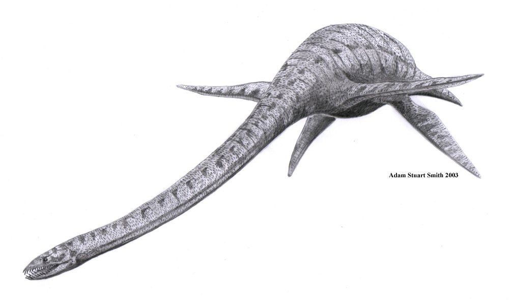
Artist sketch of elasmosaurusAccording to the National Museum researchers, there could be fossils of ancient marine predators buried under the rock at the base of the Silungan rock formation. One of the marine monsters that could be possible found is the long-necked plesiosaur called elasmosaurus, which lived 70 million years ago. Fossils of ammonites, which lived at almost the same time, have been found by Alberto at the Silungan and he has donated his find to the National Museum.

A proper expedition to the site would need funding, something which the Museum does not have. Probably, foreign scientists could take a look at the site in the near future.

Source: Catanduanes Tribune - 22 April 2009

Saturday, April 18, 2009

Lighthouse or Parola

In many movies, old lighthouses are often depicted as a rendezvous for lovers, a beckon of hope for navigators and a lure for fishermen. It is also a temporary refuge for birds and wildlife. For designers and builders, it is a structural challenge and an engineering feat. Centuries old lighthouses still stand today in many parts of the world.


Catanduanes being an island, has numerous lighthouses. Designs and sizes varies, the most modern of which, is located on Panay Island in Panganiban (Payo). It is fully automated and solar powered.

Decades ago, most of these lighthouses are kerosene powered and manually operated. A lighthouse keeper has to brave the dark, armed only with a flashlight, matches and a torch, rain or shine, just to get his job done. Possibly, a challenging task and extremely dangerous job when one has to cross a sea during a stormy weather.

This one is possibly the smallest of its kind, one located in Batalay, Bato. Perhaps, this one is a navigational aid to warn navigators of a shallow part or reef nearby.

This one in Gigmoto, can be mistaken for a watch tower, a very simple yet designed to last.

The extreme location, design and surroundings of lighthouses, makes it a good inspiration for a romantic plot and an interesting background for a movie scene.

RELATED LINKS:

Monday, April 13, 2009

Glimpse of Catanduanes Watershed Forest Reserve

These photos taken in 2007 at the Catanduanes Watershed Forest Reserve, a protected area. Twenty-two years after being proclaimed as a forest reserve, now a part (500 hectares) of it, is under threat of inclusion in the looming coal mining operation on the island. Please view the map below.

The white line on the map is the area proclaimed as Catanduanes Watershed Forest Reserve on June 23, 1987 under Proclamation No. 123 by the former President Corazon C. Aquino. A 26,010 hectares of forested areas, covering the municipalities of Virac, San Andres, Caramoran, San Miguel and Baras.

...maybe, its about time to know the true value of our forest, now, and not by the time they are gone, permanently and irreversibly damaged.

RELATED LINKS:

Saturday, April 11, 2009

Churches in Catanduanes

Catanduanes is composed of 11 municipalities, but there are 18 parishes distributed island wide. There are 3 parishes in the capital town Virac, 3 in Viga, 3 in Bato and 2 in San Andres. Although radical architectural changes have been made in many of the centuries old churches. From baroque to contemporary architecture and basic structural changes from coral stones to cement. Still many of the old practices and traditions are revered and observed up to this day. Happy Easter!

Vicariate of Our Lady of the Immaculate Conception
Vicar Forane: Rt. Rev. Msgr. Jose B. Molina, PA, VG

Virac Cathedral (F-1755), Virac 4800 Catanduanes
Population: 42,045; Catholics: 41,204
Titular: Our Lady of the Immaculate Conception, December 8
Parish Priest: Rev. Msgr. Jose B. Molina, PA, VG
Parochial Vicars: Fr. Allan Martin Basilio, Fr. Joseph Saratan, Fr. Pascual Macuja (Retired, In Residence), Fr. Sid Jose Sanchez, Fr. Paul I. Isorena

Cabugao (F-1911), Bato 4801 Catanduanes
Population: 9,288; Catholics: 9,185
Titular: St. Anthony of Padua, June 13
Parish Priest: Fr. Francis M. Sarmiento

Magnesia (F-1956), Virac 4800 Catanduanes
Population: 5,713; Catholics: 5,427
Titular: St. Isidore The Farmer, May 15
Parish Priest: Fr. Constantino Soriao

Palta (F-1955), Virac 4800 Catanduanes
Population: 6,037; Catholics: 6,018
Titular: Our Lady of Salvation, May 24
Parish Priest: Fr. Virgilio R. Bea

Vicariate of St. John the Baptist
Vicar Forane: Fr. Juan Lizaso, Jr.

Bato (F-1830), 4801 Catanduanes
Population: 17,858; Catholics: 17,643
Titular: St. John The Baptist, June 24
Parish Priest: Fr. Laudemer Jose Gapaz
Parochial Vicar: Fr. Allan Pereyra

Holy Cross Shrine (F-1576), Batalay, Bato 4801 Catanduanes
Rector: Fr. Laudemer Jose Gapaz

Baras (F-1897), 4803 Catanduanes
Population: 12,790; Catholics: 12,522
Titular: St. Lawrence, August 10
Parish Priest: Fr. Eduardo Manibale

Gigmoto (F-1951), 4804 Catanduanes
Population: 7,275; Catholics: 7,246
Titular: St. Isidore the Farmer, May 15
Parish Priest: Fr. Fernando Genogaling

San Miguel (F-1953), 4802 Catanduanes
Population: 13,016; Catholics: 12,677
Titular: St. Michael the Archangel, May 8
Parish Priest: Fr. Juan Lizaso, Jr.
Parochial Vicar: Fr. Leonardo B. Tamayo, Jr.

Vicariate of St. Andrew the Apostle
Vicar Forane: Fr. Vicente Borre III

San Andres (F-1798), 4810 Catanduanes
Population: 22,864; Catholics: 22,407
Titular: St. Andrew, November 30
Parish Priest: Fr. Vicente A. Borre III
Parochial Vicar: Fr. Jose Peña, Fr. Joel Rama

Caramoran (F-1600), 4808 Catanduanes
Population: 23,720; Catholics: 21,822
Titular: St. John The Baptist, June 24
Parish Priest: Fr. Jose C. Tejada
Parochial Vicar: Fr. Avelino Sualibio

Manambrag (F-1953), San Andres 4810 Catanduanes
Population: 9,798; Catholics: 9,601
Titular: St. Isidore The Farmer, May 15
Parish Priest: Fr. Renato de la Rosa

Pandan (F-1650), 4809 Catanduanes
Population: 16,983; Catholics: 16,813
Titular: St. Ignatius of Loyola, July 31
Parish Priest: Fr. Edison Bernardo
Parochial Vicar: Fr. Benedicto Tugano

Vicariate of Our Lady of the Assumption
Vicar Forane: Very Rev. Fr. Leandro S. Atutubo, Jr.

Viga (F-1661), 4805 Catanduanes
Population: 9,626; Catholics: 9,385
Titular: Our Lady of the Assumption, August 15
Parish Priest: Fr. Leandro S. Atutubo, Jr.
Parochial Vicars: Fr. Arnel M. Barba

Bagamanoc (F-1929), 4807 Catanduanes
Population: 11,240; Catholics: 11,205
Titular: St. Anthony of Padua, June 13
Parish Priest: Fr. Felipe S. Faustino
Parochial Vicar: Fr. Rolando de la Rosa

Panganiban (F-1683), 4806 Catanduanes
Population: 16,983; Catholics: 16,812
Titular: St. James The Greater, July 25
Parish Priest: Fr. Joseph O. Infante

Oco (F-1811), Viga 4805 Catanduanes
Population: 5,615; Catholics: 5,384
Titular: St. Joseph, May 1
Parish Priest: Fr. Felix B. Mira

Tambongon (F-1952), Viga 4805 Catanduanes
Population: 4,612; Catholics: 4,602
Titular: Our Lady of Mount Carmel, July 16
Parish Admin.: Fr. Juan Tejerero

Source: http://www.cbcponline.net/virac/index.html

RELATED LINKS:

Sunday, April 5, 2009

Tatoy Falls in Barangay Kilikilihan

Unknown to many, there are many waterfalls that could be a good place to visit this summer, two in Barangay Kilikilihan in San Miguel, Tatoy and Imog falls. Roughly an one hour ride from Virac and same if coming from Viga. This small village is located at the heart of the island, population as of 2007 census is 996. Please view the videos of Tatoy falls and its surroundings.


RELATED LINKS:

Tuesday, March 31, 2009

Twin Rock Beach Resort

Located at Igang, Virac Catanduanes. Barely 15 minutes drive from Virac Domestic airport and around 30 minutes drive from Virac seaport. The resort can be viewed while on board the ferry boat.

Resort offers the comforts and luxury of modern day living amid the verdant surroundings. The last time I went to visit this resort was several years ago.

Took the morning flight from Manila to Virac and spend sometime here swimming and headed home later in the afternoon.

Twin Rock is apparently the most advertised and photographed resort in the island.

RELATED LINKS:

An Urban Legend

Reading online threads, blogs, testimonials, analysis and historical accounts about the fate of Fray Diego de Herrera and the crew of galleon Espiritu Santo leads me to conclude it as an urban legend. The characters are factual but the story was distorted, exaggerated and sensationalized.

Sunset at Suchan beach.Here is another version about the fate of Fray Diego de Herrera written by Fray Juan de Medina, O.S.A. in 1630 but printed in Manila in 1983. Please read...
"In these early years a disaster befalls the Augustinians, and somewhat dashes their hopes. This is the death of Diego de Herrera with ten priests who are coming, six from Spain and four from Mexico, to augment the missionary efforts. Of the thirty-six priests obtained by Herrera on his mission to Spain, but six set sail for the Philippines. The four from Mexico who join them are: Francisco Martinez, of the chair of writing in the University of Mexico, an excellent Greek and Latin student, who had been prior of the Augustinian convent in Lima, Lesmes de Santiago, an ascetic, and formerly a successful merchant; Francisco Bello; and Francisco de Arevalo. The shipwreck is quite near Manila and is due "to the carelessness of the pilot--and I think that this is the first ship that has suffered shipwreck on coming from Mejico." The loss of Herrera is felt keenly, for he was an enthusiastic and zealous worker. "The loss of this ship was felt keenly in the islands, for it bore heavy reinforcements of troops, money, and other things needed in the new land, which lacked everything. But above all they were anxious because they were surrounded on all sides by enemies, and had but few troops, and these were scattered in many districts. But those who grieved most were Ours...." Medina continues"

Chapter XIX
_Of other events, and when the other religious entered into the islands_

The Project Gutenberg EBook of The Philippine Islands, 1493-1898, Volume XXIII, 1629-30, by Various
In observance of the lenten season, let us include in our prayers the late Fray Diego de Herrera, may he rest in peace.

Suggestion: A movement is seeking to beatify the fray and mentioned was carbon-dating technology possibly for authentication purposes. If indeed they are serious, they can opt to have a DNA profile on the remains and compare it with Fray Diego de Herrera's relatives. The most accurate and appropriate technology for identification purposes in this century. The University of the Philippines in Diliman and the National Bureau of Investigation (NBI), I understand, have a DNA profiling laboratory.

Sunday, March 29, 2009

Maribina Falls

Maribina falls was named after the Barangays Marinawa and Binanwahan in the municipality of Bato. Perhaps, the most popular and widely publicized among the numerous waterfalls in Catanduanes.

Of the numerous falls in the island, only a few were photograph and documented. Many are still waiting to be discovered because some locals don't want to share it with the outside world.

One of the common fears by many locals for not sharing is, they want it exclusively for their family, close friends and relatives. Although this attitude is gradually changing.

RELATED LINKS:

Tuesday, March 24, 2009

The Batalay Shrine

The site of the first cross in Catanduanes, believed to have been constructed over the grave of the shipwrecked Fr. Diego de Herrera of the Augustinian order in 1576, who died in the barangay of Batalay. A well believed to have water with healing powers can be found in this shrine. From the town proper of Bato, it would take only 15 minutes to reach this place.


batalay shrine, catanduanes, tourismReading the online historical accounts about the fate of Fray Diego de Herrera and Espiritu Santo crew, I found some interesting yet inconclusive accounts as to what really happened.
"Located at the Southeastern coast of Catanduanes is a reef called Nagngangang Buaya which is linked by traditional with the place where a Galleon Espiritu Santo taken by Fray Diego de Herrera and nine other companies which embarked from Mexico suffered shipwreck on April 25, 1576 on their way to Cebu because of the negligence of the pilot of the ship and bad weather." - wikipedia
In October last year, the Historical and Nautical Archaeology Foundation (HNAF) in cooperation with the Philippine National Museum conducted an expedition to scour the waters off the northeastern shores of Catanduanes in search for the galleon shipwrecks of San Geronimo and Espiritu Santo, believed to have sunked in 1576, apparently by bad weather. But the search was aborted because of the controversial magnetite mining in Bagamanoc at that time.

batalay shrine, catanduanes, tourismIf were to believe that Espiritu Santo was shipwrecked in the reef called Nagngangang Buaya in Bato because of negligence and bad weather, then the HNAF expedition is searching at the wrong site.

Though there maybe a lot of speculations and theories as to what really happened in April 25, 1576. Possibly the galleon Espiritu Santo was lost on their way to Cebu and ran aground at the coral reefs in Nagngangang Buaya due to poor visibility caused by fog or a mutiny was taking place inside the galleon. Blaming it to bad weather would be unlikely because April is the onset of summer season in Catanduanes.

Hope that the HNAF search expedition would resume this year to shed light on what really happened.

RELATED LINKS:

Wednesday, March 18, 2009

Wildlife in Catanduanes

Moving around the island, particularly in the remote barangays located in the hinterlands, one can find unusual pets and not often seen animals, some were hunted down to near extinction.

Monkeys or "ukay" are teeming in some parts of the island, often a menace to small farmers' crops.

Wild chickenWild chicken or "abukid" are at times sold as pets by ambulant vendors. The look is no different from a domesticated chicken but I think its smaller and lighter.

Philippine DeerLong ago wild deers or "usa" can be found in the lowlands and some even tried domesticating this wild animal. But in later years their population had drastically diminished.

Philippine DeerSame with the wild pig or "opon", a delicacy for many because of less fat and tastier compared to hybrids. The look is very much different from domesticated pigs, mean looking, small and hairy.

Philippine CobraA dreaded species of Philippine cobra or "haras" as the locals calls it, is found also in the island, but record of snake bites is almost nil.

Tuesday, March 17, 2009

Puraran Beach

Probably the most popular tourist destination in the island is Puraran in Baras Catanduanes. It is the home of the well-known “Majestic” waves with its awesome long-barrel-type surf. Offshore waves are in their utmost shape during the months of August to September.

The area around Puraran also shows marvelous view of mountains and bays. Photo enthusiasts could also get a great view of the sunrise in this area.

For holiday seekers, this place is for total relaxation, be in touch with nature, bird watch, camp and simply stargaze at night.

Puraran is accessible both by public and private vehicles. An hour and 45 minutes ride from the capital town of Virac, that passes through the old Bato Church and the longest bridge in the island. At the approach of the bridge, you can view the ruins of the old concrete bridge washed away by floods during one of the worst typhoon in this island's history.

Note that Catanduanes is considered to have the highest rainfall in the country. Best time to visit is April-June and worst is November-January.

RELATED LINKS:

Monday, March 16, 2009

Bird Watching in Catanduanes

Many of the threatened and restricted-range birds of the Luzon Endemic Bird Area have been recorded on Catanduanes. Extensive lowland forests are reported to remain there, so it could support important populations of many of these birds. This is one of the few islands near Luzon where there has been a relatively recent record of Philippine Cockatoo, and Cream-bellied Fruit-dove appears to be particularly numerous there. Two of the restricted-range species are represented on Catanduanes by endemic subspecies, Luzon Bleeding-heart G. l. rubiventris and Grey-backed Tailorbird O. d. nilesi.

Philippine CockatooPhilippine Cockatoo Cacatua haematuropygia 2008 IUCN Red List Category: Critically Endangered

Cream Bellied Fruit DoveCream-bellied Fruit-dove 2008 IUCN Red List Category: Near Threatened

Luzon Bleeding-heartLuzon Bleeding-heart (Gallicolumba luzonica)2008 IUCN Red List Category Near Threatened

Grey-backed TailorbirdGrey-backed Tailorbird (Orthotomus derbianus) 2008 Red List Category Least Concern

Philippine Dwarf KingfisherPhilippine Dwarf-kingfisher (Ceyx Melanurus) 2008 IUCN Red List Category: Vulnerable

Philippine Eagle OwlPhilippine Eagle-Owl (Bubo Philippensis) 2008 IUCN Red List Category: Vulnerable Philippine DuckPhilippine Duck ( Anas luzonica) 2008 IUCN Red List Category: Vulnerable

Citation BirdLife International 2008 BirdLife's online World Bird Database: the site for bird conservation. Version 2.1. Cambridge, UK: BirdLife International. Available: http://www.birdlife.org (accessed 17/3/2009)

Sunday, March 15, 2009

Catanduanes Watershed Forest Reserve

Site description: Catanduanes is an island of 182,300 ha which lies about 10 km off the tip of the Caramoan Peninsula in southern Luzon. The terrain on the island is hilly, particularly in the central portion, but the highest point only reaches just over 800 m. The substantial forests which remain in central Catanduanes are therefore all lowland dipterocarp in type, and are the largest remaining forest block in the whole of the Bicol Region.


Mountains of CatanduanesForest is found above 490 m, and is estimated to cover a total of about 69,770 ha. It includes considerable areas of old growth dipterocarp forest (reported in 1997 to cover 5,876 ha), and closed-canopy forest in areas that show evidence of having been logged. These forest areas are the source of water for Catanduanes Province. One hydropower project is currently operational, that supplies power to urban areas of the island. The forest areas was proclaimed as a Watershed Reserve in 1987 because of these important function, the whole area is state-owned.

Small village and rice fieldsProtection status The Catanduanes Watershed Forest Reserve was declared through Proclamation No. 123 in 1987, and covers 26,010 ha. It is proposed as a Natural Park (see Conservation issues below) with an expanded protected area of 49,000 ha.

Clearings within the watershedConservation issues In the past, there was little evidence of timber extraction and kaingin in the forested areas of this IBA, probably a result of the local forest protection program and the low population density in the province. However, the human population of Catanduanes is increasing, which is putting pressure on natural habitats. There is evidence that people are moving into forested areas, leading to uncontrolled kaingin, land conversion, illegal cutting of trees and forest fires. As a result there has been an increased occurrence of soil erosion, landslides and siltation in some major river systems. There is also large-scale collection of forest products, hunting and pollution from household waste. Typhoon Rosing is reported to have damaged (at least temporarily) areas of natural habitat on Catanduanes in 1995.

Citation BirdLife International 2008 BirdLife's online World Bird Database: the site for bird conservation. Version 2.1. Cambridge, UK: BirdLife International. Available: http://www.birdlife.org (accessed 16/3/2009)

Wednesday, March 11, 2009

Catanduanes Beauty

This video highlights island's nature, people and places. It focuses on the unspoiled and awesome beauty of nature at its finest, photos were taken by several photo enthusiasts and tourists who visited this island paradise. Please watch the video entitled, Catanduanes Beauty.


RELATED LINKS:

Thursday, February 5, 2009

The Old LORAN Station

I only passed once at this former US Coast Guard facility on Panay island when I was a growing-up kid. At that time, the station was no longer operational, but for the locals who used to be civilian employees, for them is a continuing saga. They would tell me stories about seaplanes delivering food supplies and mails, abundant supply of corned beef, men unafraid of rough seas and radar.

In my later years, I never had a chance to see LORAN upclose, though had a chance to meet former civilian employees.

The last time I heard someone talk about it, was from a resident at Panay island. He said that the former station was completely vandalized and the new occupants now are water buffalo.

There should be an initiative to maintain the facility not only as a tourist destination but as well as a historical reminder for our province and also in memory for those who were once part of the station.

A description of the air operations at LORSTA Catanduanes:

The island of Catanduanes lies 230 miles east-southeast of Sangley Point. The hilly terrain was unsuitable for an aircraft runway. The LORSTA, known simply as Cat, was situated at the north end of the island with a bay immediately to the west that was adequate for UF/HU-16 water operations as long as the wind and sea conditions were favorable. The aircraft tied up at a buoy and supplies were unloaded by small boat and transported to the boat dock. The bay was semi-exposed to the sea and when the incoming swells made the bay dangerous, landings were made at the south end of the bay. This was separated from the main bay by an island and coral reefs. The aircraft, when using the south bay had to be unloaded at anchor and supplies transported to the LORSTA.

source: www.uscgaviationhistory.aoptero.org/history02.html
photo: www.pbase.com/cesvaleza/loran

RELATED LINKS:

Wednesday, February 4, 2009

Bato Church

This magnificently situated edifice greets everyone upon entrance to the town of Bato. It is the only remaining structure of its kind in the entire island. Despite the tests of time, wars, and ravages of natural calamities, it was able to retain its old glory of massive structure of mortar and coral stones. It took 53 years, from 1830 to 1883, to build this Church under six different parish administrators.


RELATED LINKS:

Monday, February 2, 2009

Usual Sights Around The Island

If one is a tourist or a first time traveler, scenes like an overloaded tricycle is a usual sight around the island. Just be safe and have fun.


RELATED LINKS:

Sunday, February 1, 2009

Sights In The Northern Part

There are many undiscovered sights in Catanduanes if one is to travel northward. Here are some photos taken at Nahulugan Falls in Gigmoto, Lolong Point lighthouse on Panay Island in Panganiban and Boto ni Kurakog in Bagamanoc. Within Panay island, one can find the old ruins of the former US Naval Station called LORAN (Long Range Aid To Navigation) established in 1953 and disestablished in 1972.


RELATED ARTICLES:
  • Must-See Sights in Catanduanes - Partial lists of sights in the more accessible and populated southern part of the island.
  • Visiting Panganiban - A northern town, popular for mud crabs and beaches in Panay island.
  • Visiting Bagamanoc - A coastal town in the north and adjacent to the former US Coast Guard LORAN station in Panay.
  • Visiting Pandan - Northernmost town in the island, home to the finest beaches in the island.

Sunday, January 25, 2009

Must See Sights in Catanduanes

I received an email a week ago asking me about must-see places and landmarks in Catanduanes to be featured on a local travel magazine. Mentioned were Maribina Falls, Virac Cathedral, Bato church, Puraran and Amenia beach all located in Virac, San Andres and Bato.

There are eight more towns in the island with sights and landmarks unheard of, like the former US Coast Guard Station - LORAN, Lolong Point Lighthouse, Boto ni Kurakog, Nahulugan Falls, Del Rio River resort and many others.

RELATED LINKS:
google-site-verification: googlea4d68ed16ed2eea6.html